Mt Williamson, Mt Tyndall, Split Mountain
Sierra Nevada Climbing
Sierra 14ers
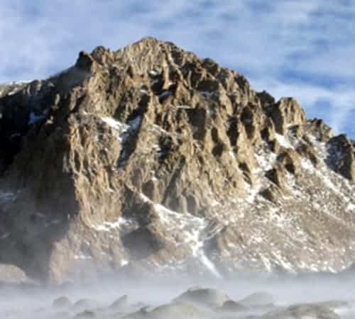
Mt Williamson - 14,379ft
$1,895.00 Per Person
3 day / 2 nights
Mt Williamson, the second-highest peak in the Sierra Nevada. The standard route is along the West Side, and accessed from Shepherd’s Pass. We’ll travel across the Williamson Bowl, which lies between Mount Williamson and Mt Tyndall as approached from the pass. The Williamson bowl is part of the Sierra Crest, and home to five high alpine lakes. The route climbs gullies up the west face to the relatively broad summit plateau; this portion involves climbing up to class 3/4 as rated by the Yosemite Decimal System. Other routes exist on the mountain, including a significant technical route on the North Rib class 5.7 grade IV and is considered one of the finest routes in all the Sierra Nevada climbing options.

Mt Tyndall - 14,025ft
$1,895.00 Per Person
3 day / 2 nights
Mt Tyndall is a peak just north of the Mt Whitney region of the Sierra Nevada. It’s just west of the much higher Mt Williamson. Mt Tyndall is the tenth highest in the Sierra range and can be done together with Mt Williamson, the second-highest peak. The North Ridge is our recommended route. This is a 3rd/4th class climb to the summit offering scrambling and boulder hopping until you reach the airy ridge. From there, we’ll follow it up to the summit. Mt Tyndall has a striking view all around and gives a feel as though you’re in the center of the Range of Light.

Split Mountain - 14,064ft
$1,895.00 Per Person
3 day / 2 nights
Split Mountain is one of the easier California 14ers. The most straightforward climb is the North slope, it’s considered a class 2 route. If you’re wanting, more technical routes can be found on both the North and South peaks of Split Mountain and are classic Sierra Nevada climbing options. These routes are approached from the West or East sides of the range. A more common route to the North face is from the East, by way of Red Lake. Starting at the Red Lake trailhead, this trail covers 6 miles (10 km) with 4,000 feet (1,220 m) of elevation gain one way to the lake. From here, another 3,500 ft (1,070 m) of cross-country climbing, including a short class 3 ridge traverse, leads to the summit.